Kat Crowley, M.S. Environmental Science and Policy student, edited by faculty advisor Mary Ann McGarry
Historic Flooding (Pre-2000)
To early settlers, Livermore Falls seemed an ideal place for a mill: rushing water constricted by the bedrock gorge and plenty of timber to build the powerhouse and dam. The first mill was constructed in 1773 and various mill operations ran until 1950. Unfortunately for the mill owners, natural disasters —floods and fires — occurred with astonishing frequency and forced mill owners to rebuild often. The worst flood, nicknamed the “Pemi Flood,” happened in June 1973, when Hurricane Agnes devastated the dam and powerhouse at Livermore Falls. Fortunately, mill operations had ceased decades prior.
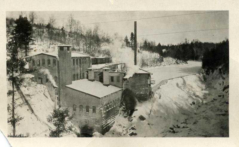
In 1988, an organization attempted to create a hydropower facility at Livermore Falls, but the Federal Regulatory Energy Commission denied the permit due to flooding concerns. A study showed that the hydropower facility could have caused flooding as far upstream as North Woodstock, about 15 miles away. Although dams can reduce flooding by storing floodwater and releasing it slowly, when the stored floodwater is not released quickly enough it causes further flooding upstream.
Any future opportunity to rebuild the dam was terminated in 1991 when the New Hampshire Legislature passed HB674. This bill designated the Pemigewasset River to the New Hampshire Rivers Management and Protection Program, preventing dams from being constructed on the Pemi. This decision protects the Pemi from future flow alterations and prevents additional barriers that would impede migratory fish species’ passage.
Current Flooding (Post-2000)
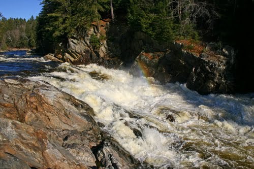
The sound of rushing water greets me as I arrive at Livermore Falls Beach. As I walk across the sand toward the Pemigewasset River, I think of how different this landscape looked a year ago at the height of the October 30th, 2017 flood. During that storm, the Pemi River rose from 2.5 feet to nearly 20 feet and flooded Holderness near the Plymouth State University Ice Arena and the Holderness I-93 exit. The Livermore Falls Beach was flooded and the falls were nearly unrecognizable, swollen and angry from the storm flow.
Although this storm was touted as a 100-year flood, it was really closer to a 10-year flood. People often have the misconception that a 100-year flood can only happen (or is only supposed to happen) once in a hundred years. In reality, this number refers to the probability of flooding each year. A two-year flood has a 50% probability of occurring every year, a 10-year flood has a 10% probability, a 100-year flood has a 1% probability, and so on.
You may protest: If a 100-year flood has a 1% probability each year, doesn’t that still mean that it only happens once every hundred years? Yes, in theory, a 100-year flood should happen once every hundred years on average. Flip a coin a few times. Does it land on heads every other time, perfectly? Probably not. But if you flipped it a hundred times, it should land on heads about 50% of the time.

Flipping Image via Shutterstock
These flood frequencies are based on historical data, and assume that storm frequency and intensity will remain constant. However, if larger storms continue to occur, the magnitude of these 10-year flood and 100-year flood events will increase: what was once a 100-year flood shifts toward a 10-year flood. Several other storm events of the magnitude of the October 2017 storm have impacted communities around the Pemi River in recent memory. In late August 2011, rain fell at the rate of 1-1.5”/hour for several hours during Hurricane Irene and the Pemi River rose 20 feet. The February 2017 ice jam flood submerged the Plymouth State University commuter lot and destroyed dozens of cars. The July 2017 flood destroyed sections of Route 25A, a well-traveled road.
Why are these floods becoming more common? As development creeps into the floodplain of the Pemi River, the land loses its capacity to absorb all the rainwater and the river has to carry the large storm flows. Increased impervious surface cover, such as parking lots and buildings, prevent water from soaking into the ground. Instead, the water travels into the river as stormwater runoff. This creates more frequent and intense flood events and downstream communities suffer.
Future Flooding
As I gaze out at the Pemigewasset River from Livermore Falls Beach on this crisp fall morning, with the sound of the falls in the background, I wonder how high the water will reach during the next significant flood. Climate change is already causing more intense storm events. As the impacts of climate change become increasingly evident, floods like the one in August 2011, October 2017 and June 1973 will likely become more commonplace. How will Livermore Falls and the surrounding areas change from these flood events? What precious artifacts from this rich archeological site will be washed away? How can we adapt?

Fortunately, awareness and willingness to act is growing among communities near Livermore Falls. The Lakes Region Planning Commission surveyed people living along the Pemigewasset River corridor in 2010 and many respondents expressed concern about climate change. This issue hadn’t previously been addressed in Pemi River corridor management plans. Due to community interest, the 2013 update of the Pemi River corridor plan included five recommendations addressing increased flood risk from climate change.
These recommendations include:
- educating communities on the hazards of building in the floodplain
- encouraging towns to incorporate low impact development practices in local regulations
- encouraging communities to consider the impacts of more frequent storm events
- encouraging towns to adopt stormwater management ordinances
- mapping areas susceptible to severe erosion using fluvial erosion hazard mapping.
If towns adopt these recommendations, our problems won’t disappear. We’ve altered the landscape in the Pemigewasset River corridor so significantly it will be hard to turn back, and so we will continue to see impacts from these changes for generations. However, these recommendations could mitigate the worst of the flooding and potentially prevent loss of property and, more importantly, loss of life. Our best hope moving forward is to maintain at least and ideally restore the river’s access to its floodplains as much as possible to better adapt to more intense storms and larger magnitude flood events.
Resources:
“Historical Gallery.” Friends of the Pemi Livermore Falls Chapter, livermorefalls.org/historic-photos/.
“Environmental Gallery.” Friends of the Pemi Livermore Falls Chapter, http://livermorefalls.org/environmental-gallery/
“Livermore Falls Gorge: A Timeline.” Friends of the Pemi Livermore Falls Chapter, http://livermorefalls.org/wp-content/uploads/Historic-Timeline-.pd
WMUR-TV. “Raw Video: Pemigewasset River Rages after October Storm.” YouTube, 30 Oct. 2017, www.youtube.com/watch?v=7lgPPckGZGA.
Pemigewasset River Local Advisory Committee. “Pemigewasset River Corridor Plan.” Department of Environmental Services, 2013, https://www.des.nh.gov/organization/divisions/water/wmb/rivers/documents/pemi-plan.pdf
Gray & Pape, Inc. “Cultural Landscape Report and Environmental Assessment: Livermore Falls, Grafton County, New Hampshire.” 22 Dec. 2015.