Last updated on February 2, 2022
Concept:
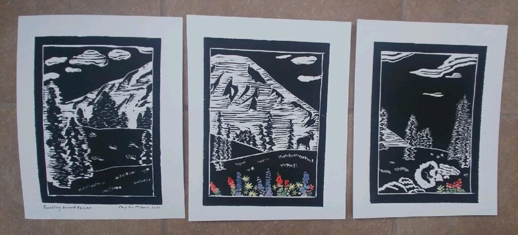
I wanted to create an image that was meaningful and significant to Phil Park, who is from Seattle, Washington and has a great love for his home state where his mom Julie still lives in the home where she raised Phil and his sister. In the summer of 2021, he introduced my daughter Sydney Kahl, his girlfriend, to the state of Washington, specifically Mt. Rainier and the Cascades.
Mt. Rainier, with an elevation of 14,411 feet, is the highest mountain in Washington and is an active stratovolcano, 59 miles south-southeast of Seattle. I have studied and taught about volcanoes, but I have never visited Mt. Rainier or Washington.
Mount Rainier is the most hazardous volcano in the Cascades in terms of its potential for eruption and the risk of producing debris flows of lava and ash and lahars or mudflows from melting snow and glacial ice. The pink summit area around Mt. Rainier is the cone where the most explosive activity would happen and the orange and yellow are the paths of the lahars, which follow riverbeds. Risk assessment maps are in part made from mapping evidence of past eruptions. Thousands of people’s homes could be impacted. The potential hazards on and around Mt. Rainier led to it being included as one of the sixteen designated Decade Volcanoes worldwide. My academic sabbatical in 2013 focused on two “Decade Volcanoes” in Italy- Etna and Vesuvius.
I have taught about the cone shaped volcanoes in the Northwest caused by the subducting oceanic Juan De Fuca crustal plate beneath the Pacific Ocean moving below the North American plate. The friction of the two plates colliding creates the north south running chain of strato- or composite volcanoes in Oregon and Washington. These volcanoes have alternating, sequential layers of ash and lava from a series of past eruptions.
Mt. Rainier’s last significant eruption was 500 years ago; and in 1894 there just summit explosions. The next eruption could be small or large, producing volcanic ash, lava flows, intensely hot rock and volcanic gases called “pyroclastic flows,” and lahars. Ideally development should not occur where past flow deposits have been mapped, part of the purpose of a risk assessment map, but one can see many towns in the path of future lahars. Humans have a hard time accepting risks and potential impacts of events that occur so infrequently in geologic time. As the population in the area continues to increase so does the risk.
Regarding the fauna around Mount Rainier, this is the most southern national park where one can see mountain goats in their native habitat. The park is the southern edge of the natural range of these beautiful alpine animals. Mountain goats are only found in North America, and are native to five National Parks: Glacier, North Cascades, Rainier, Kenai Fjords, and Glacier Bay. They have been introduced to Yellowstone, Grand Teton, and Rocky Mountain National Parks.
Mount Rainier National Park .GOV/www.nps.gov (left image) and USGS risk assessment map
Execution:
With each new printing project, I like to take on a new challenge. I decided to go for a triptych- a three-part piece of art. Each of the three sections fit together and contain a part of the image of Mt. Rainier. The three sections are printed and framed separately.
Adding two animals was important as they represent the wildlife of the region. My daughter Sydney posted photos and made comments about seeing the mountain goats and marmots. While creating the artwork, Sydney informed me that lupines were Phil’s dad’s favorite flower and Indian paint brush was his mom’s favorite. Phil lost his father to cancer when he was a sophomore in college. To emphasize the flowers, I decided to add my first watercolor pigments to one of my prints, blue for the lupine and reddish/orange for the Indian paint brush.
In creating the image, I had to think of scale, an appropriate size for the mountain goat a bit in the distance, with the flowers and marmot closer up. I had to distinguish the sky from the mostly snow-covered white mountain and did so by leaving the sky dark and including clouds. Carving trees was a big part of this scene. I wanted more than just outlines of the shapes.
I wanted each of the tree sections of the triptych to be able to hang on its own and be appealing – a complete composition.
I used a printing press to achieve an embossed effect.
Reflection:
I enjoyed being in the Littleton Studio School, in Littleton, NH, for studio hours, as it meant I could spread out, take my time, and have the printing press to myself. The President of the School came up to watch me in action. She saw the final products and gushed over the outcome. Later she asked me to email her a photo as she “couldn’t get the images out of her mind:” with that kind of interest and endorsement I was happy to oblige.
As a retired environmental science and policy professor, my goal in producing art is to educate others about an aspect of the natural world, in this case the ecology and geology of Mt. Rainier National Park, the most glaciated peak in the “lower 48” or contiguous U.S. The massive mountain is the source of five major rivers- the Carbon, White, Cowlitz, Nisqually and Puyallup. There is unique wildlife and subalpine wildflower meadows. After my daughter’s rave reviews, (she has backpacked on the South Island of New Zealand and climbed peaks in Colorado and the 115 highest in New England and New York, so she has something to compare the mountains with) I know I must visit.